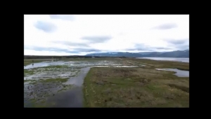
Drone Tour of the Wairio wetlands
Watch the Drone Tour of the wetlands that was created by the Victoria University Research team
Drone view flying over the Wairio Complex
What changes in vegetation cover over time are evident at Wairio?
To what extent is the accuracy of the image classification process improved with the addition of ancillary data?
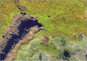
This project investigates the use of image classification techniques to create detailed maps of wetland areas based on aerial photographs.
The project uses an emerging set of analysis methods called ‘object-based image analysis’ to investigate the applications of remote identification techniques calibrated to detect selected native and invasive species.
An additional objective is to compare and contrast the improvements that including ancillary data into the classification process, such as 3D digital surface models (DSMs) or near infrared imagery, may have over classifications based solely on true-colour images.
The processes being evaluated by this project may allow teams with limited budgets or time to quickly and accurately convert imagery into maps with much greater levels of details, which will improve their ability to detect and track specific plant species.
This is especially useful in the case of wetlands undergoing restoration as they often exhibit significant changes over time, and the target species would normally be challenging to differentiate from one another in an aerial photograph.
Though the study is ongoing, with flights every three months, the initial results would appear to confirm that a ‘true-colour only’ classification would perform poorly compared with ancillary data. The improving effects of including infrared imagery will be tested once that has been gathered.
The classified images contain between 18 and 20 distinct classes.
The Wairio wetland was drained and converted into farmland in the 1960s.
Since 2005, it has been undergoing a managed restoration programme to return it to something approaching its natural state.
Several plantations of native plants have been established, and a weed eradication programme to control invasive species such as Bidens frondosa is in progress. This project can assist this effort by tracking the distribution of natives and weeds.
Object-based image analysis works on the principle that different types of surface cover have unique properties, such as colour, texture or shape.
For instance, weed species might be distinguished from grass as the weeds may be a different shade of green to the surrounding grass, or present a unique textural pattern owing to differently shaped leaves.
The sensors being used in this project are the DJI Phantom 4 Pro Camera, to collect true colour imagery, and a Micasense RedEdge-M, a multispectral sensor for collecting near infrared imagery. The software is ArcGIS Pro 21, ENVI 5.4 and PrecisionMapper 3.32
A busy day at Wairio:
There was a digger on site to raise the walking track.
The success of retaining water in the wetland has required this work. Also the need to clear a few culverts to allow the water to flow more easily from Stage 4 (in the slightly higher ground in the north of the wetland) to the Stage 3 area. Though there is still plenty of work in progress and the need to equalise the water level.
There is new walking track signage made by DOC. That will be a big help for those interested in exploring the area.
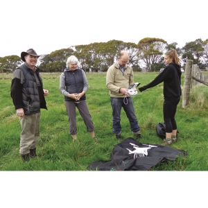
And lastly, Stephen Hartley from Victoria University (with helpers Maxine, Veronica and our own Ross Cottle) starting a drone flight to record vegetation and water levels, principally in the Stage 3 research area.