Displaying items by tag: Wetland Development
Planting continues at Wairio wetland
The water was quite high at Stage 4 so there are still some spots to be planted.
We still have 400 suitable plants at Norfolk Road Nursery and Don Bell will arrange for them to be planted when the water recedes. He will also plant about 100 Totara and
We did not do this during the July planting due to time constraints – priority was on getting the trees in the ground.
Jim Law
Wairio work
Tree protection trial
The accompanying photos show Cabbage and Totora trees planted in Grotectors (tree protectors) at Stage 2 in the Wairio Wetland.
They were designed by Don Bell, a DU member who has been involved with the Wairio Restoration Project since its inception. These protectors are being monitored as part of the various plant survival studies being conducted by Victoria University students. It is also hoped to get students from a local secondary school involved in the monitoring process.
As the photos indicate, the plants protected seem to be doing well versus their unprotected neighbours that were similarly planted on spot sprayed sites. In addition to enhancing growth rates, the sheer visibility of the Grotector enables easy follow-up release spraying.
Based on the good results from 2013 the restoration committee decided to use these protectors for the larger plant species this year, especially Kahikatea and Totora.
Rotary support at Wairio
The South Wairarapa Rotary Club (SWRC) recently made a $1600 grant towards the restoration of the Wairio Wetland. The SWRC has contributed $14,480 in total since 2007 – they have been great supporters of this project.
It is one of the long-term environmental projects they support in the South Wairarapa.
In addition to the cash contribution that goes towards the cost of plants (sedges, flaxes and specimen trees, the likes of Totora and Kahikatea) being used in the restoration of the Wetland Rotary members assist in the planting days. It is one way Rotary both contributes to, and participates in community activities. DU certainly appreciate the contributions.
Wet day planting at Wairio Wetland
A team of environmental enthusiasts turned up in late April for this year’s first planting at the Wairio Wetland. It was a wet day, great for the plants and not too bad for the enthusiasts but coats were definitely required!
Planters included a great team of young women from Taratahi’s equine school who worked tirelessly in the rain. There were the usual Ducks Unlimited stalwarts and representatives from Greater Wellington Regional Council and Doc. Unfortunately, attendance by teams of students from the local primary schools had to be cancelled because of the wet weather. A GWRC team also put on a BBQ that was most popular once the allotted 650 plants were in the ground.
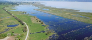
The planting was in a newly fenced off area of Stage 4 along the south eastern fringe of the wetland improved by the construction of a bund wall during 2013. This area has become very popular with local waterfowl with hundreds of ducks, swans and native waders taking flight when the planters arrived. In the years to come waterfowl will be able to fly into a much enhanced wetland as a result of the good work by the planters.
The next planting was July 4. Hope they had a great day.
Arbor Day planting a tradition
Seven classes from Waikanae and Kapanui Schools were ‘eager beavers’ on Friday June 6, when around 1700 plants were planted on the west margin of the northern pond at the Pharazyn Reserve wetland near Waikanae.
The two local schools have been involved for some years now and the planting is a popular activity with the students.
This latest planting complements work done in previous years in the programme to re-habilitate a wetland margin around the former oxidation ponds for Waikanae that were de-commissioned in 2002.
To date approximately half of the margins have been planted over the last seven to eight years. The earlier plantings are doing extremely well with a number of the students proudly pointing out where they had planted in previous years.
Matthews Lagoon project approved
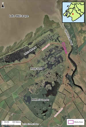
A proposal to divert water from Matthews Lagoon through Wairio wetland has been given the green light.
DU President Ross Cottle says he is delighted that the consent process has been finalised and work on “the final major part of the Wairio story to get a permanent water supply” is about to begin.
The project, a collaboration with Ducks Unlimited, the Department of Conservation and Greater Wellington Regional Council (GWRC) is part of a longer term plan to restore the eastern shores of Lake Wairarapa to a fully functioning wetland with thriving native flora and fauna, says Aprille Gillon, GWRC biodiversity advisor – wetlands.
Diverting water from the lagoon will lead to increased water levels in Wairio, and a better habitat for wetland plants and birds. It will also play a vital role in better filtering nutrients and sediment from the water.
Runoff from 1000 hectares of farmland is pumped into Matthews Lagoon via Te Hopai Pump Station and this water ends up in Lake Wairarapa by travelling through two culverts into the Oporua Spillway and out of a drain.
A 10-year resource consent has been granted for the work to build the diversion into Wairio wetland and it will involve creating a channel for water to flow into a low-lying area at the northern end of the wetland.
“We are currently creating a fish passage monitoring plan as well as a restoration project monitoring plan,” Aprille says. “We’re looking forward to seeing how this project develops and closely monitoring the impact on wetland habitat as well as water quality.”
There’s a road through these wetlands
Gordon Pilone tells the story of how Pohangina Wetlands, now protected by a QEII National Trust covenant, were created
In 1995 Gordon and Anne Pilone bought a lifestyle block in Pohangina Valley, retiring there from Palmerston North where Gordon, originally from California, had lectured on and researched microbiology at Massey University and Taranaki-born Anne had established the best veggie and landscape gardens in town, which would prove valuable experience later.
Beside the Pilone property, sheep and bulls were grazing on a very wet paddock with some remnant kahikatea (New Zealand white pine) and other wetland flora struggling to survive. This farmland, owned by Finnis Farming Company (John and Mary Culling), had historically challenged owners’ efforts to drain it.
Across the road was the well-established Luttrells White Pine Gardens and Museum. The
gardens had walking tracks but only one small pond to attract wetland wildlife. And so began Gordon and Anne’s long-term retirement project to create a large, mature wetland. They set up the Gordon and Anne Pilone Charitable Trust in August 2000, and were joined by farmer and orthotist Chris Pullar and accountant Ian Mackrell as trustees. A fifth trustee, naturalist Dr Liz Grant, joined later, contributing her expertise in visual design and entomology science. All are Ducks Unlimited members.
Shaping the wetlandsThe development took off in 2001 when the trust employed contractor Kevin Large with his digger and bully to create the first pond near the main entry gate along Pohangina Rd. This is now known as the kahikatea block. Progress was slow as the wet dirt, being moved to create a pond, was used to develop the head and track along the bund, but it needed time to dry to get access.
Then in 2004 floods struck Pohangina Valley. Roads and bridges were washed away and Pohangina Rd was cut off when the culvert bridge at Sandy Creek was washed out. Pohangina Wetlands became even more soggy, but no damage occurred because the “wet” of the wetlands comes from aquifers and not directly from water flowing on the surface from creeks, streams or rivers.
Development slowed down after the flood because Kevin was involved with clean-up work in the valley but activity continued with the planting of native grasses, bushes and trees, mostly by Anne.
Because of the slope, all the surface water that overflows in the wet months flows to the southernmost part, the base of the damsite block. Until 2012, this water drained directly to the Weka St drain and the river. But Gordon found a way that this flow could be reused to establish a different habitat within the wetlands.
In 2006, work began on the second block (damsite block) and the biggest pond (0.54ha), which includes a sizeable island and a subterranean island – sometimes visible in the drier seasons.
Work on the “big pond” was challenging and a large track-dump truck and extra help
were required to take away the soil. It was also a large block (2.3ha) to plant out so Anne was flat out growing and planting and weeding. It is now maturing nicely and has a
“lookout”.
Once the damsite block was completed, Gordon convinced the other trustees that additional property would be fruitful for the future protection of the two main blocks.
The kahikatea block formed an L-shaped property with the newly developed damsite block, and the triangular block nestled in the “L” was being used for grazing. In 2010 this land was bought and designated the Culling block.
Instead of extensive pond development and native plantings, the block, essentially, is being allowed to “develop on its own”. Some earth was moved by Tim Luttrell with his small digger to provide a flow of surface water and a few flax, cabbage trees and Carex
geminata (cutty grass, rautahi) have been planted among the rushes.
The wetlands slope dramatically towards the Pohangina River, and the aquifer and surface water flows from north to south. This enabled the creation of ponds of varying depths and in the drier months, muddy areas form at the upside of the ponds. This habitat is invaluable because it attracts wading birds that feed in the “mudflats”. So watch out for pied stilts, heron, royal spoonbill, spur-winged plover, and dotterel.
Finnis Farming Co allowed the trust to acquire a small (0.2ha) parcel at the back of the damsite block from which Tim created a series of shallow ponds, with final exit of water overflowing to the Weka St drain.
Retention of water in this block is being aided by the planting of raupo (bulrush, cat-tail). This will create a new habitat and will allow shy and uncommon wetland birds to be seen such as fernbird, crakes and bittern. Even if this is wishful thinking – because the area is small – raupo swamps are ideal as filters for water purification.
Challenges along the way
Even with the best planning, things can go wrong and sometimes reworking is necessary, and costly. In 2006 it became noticeable that the big pond in the damsite block would not maintain its full overflow level for long after a wet period, but dropped quickly, exposing the subterranean island and pond bottom.
When walking along the track behind the head next to the drain, a wet patch was apparent so an exploratory ditch was dug along the pond below the base of the head. It exposed a cluster of rocks which seemed to form a drain into the head since water was trickling from them. It is likely this had been a very wet paddock, with drainage created from a ditch filled with rocks, and these were not noticed when the head of the big pond was developed. All agreed the remedy was to cut through the head and remove the rocks and rebuild it.
During a trustee tour after the Eketahuna earthquake in January 2014, it was obvious the poplar pond in the kahikatea block was extremely low. This pond is where the “waterworks” pipe crossing the pond head with an upright was built to allow discharge of the pond water to different levels. We thought it would be clever to be able to control the water level and form new habitats (for example, exposed muddy areas) at will. Well, Mother Nature thought differently.
The reason for the low water level became apparent when Anne found water leaking from the outlet side of the pond hidden in tall grass near the end of the pipe running through the head of the pond. On further inspection, there was a large crack in the plastic T-fitting at the base, which must have happened in the earthquake.
The T-fitting was held snugly by two posts and apparently there was not enough “give” when the earthquake hit. The assembly was removed and the pipe carrying water through the head was capped off on the inlet side of the pond. We learnt that careful thought needs to be given to the design of piping in a wetlands system.
Another example was during the development of the ponds in the kahikatea block. The main ponds there are connected by 110mm pipes allowing water to flow from one pond to the next underground rather than over the tracks, ensuring easier and drier access
for visitors.
Gordon had a bright idea to prevent clogging of the inlet of the pipes with surface debris: the inlets could be fitted with a short pipe at a 45-degree angle to submerge the inflow beneath the surface of the pond. Soon after this modification, he was surprised to find all the ponds had lower water levels than the expected overflow levels when the ponds were full.
The penny dropped and it became obvious that the inlet-angled pipe also allowed for siphoning to occur when the flow was great enough to fill the pipe and continue to flow to the level of the submerged inlet. A lesson learnt. And the solution was obvious, too – drill a hole at the attachment point of the angled pipe to allow the inflow of air, thus preventing siphoning.
Some other “oops” happen unexpectedly and require major adjustments. In 2011 Gordon began to have cramps in the calves of both legs. Peripheral arterial clogging was advanced and in 2015 he had to have both legs amputated above the knees. Now wheelchair-bound, Gordon is no longer physically active in the wetlands development, but fortunately the main work is complete.
Anne continues maintenance plantings
Tim Luttrell.
The Pilone home could not be readily renovated for wheelchair living but, fortuitously, a cottage being built across the road by Tim and Carol Luttrell became available and was purposefully built for wheelchair use. You will still see Gordon in the wetlands, but not on his tractor mowing or on his bright orange Kubota RTV.
Instead, he will be observing and taking pictures from a Timmobile, a mobility scooter renovated by Tim. So look out for Gordon on the tracks and have a chat, or come to the cottage across the road and say hi.
Visitors always welcome
The wetlands were opened to visitors on the longest day in December 2005 and are always open to visitors at no charge. A brochure is available at the entry gate on Pohangina Rd.
Probably one of the greatest joys in establishing a wetlands was seeing a kōtuku (white heron) visiting for a few hours in 2008. This has been a one-time event, though it may be that they visit when we are not in the wetlands.
Another uncommon visitor is the New Zealand royal spoonbill (kōtuku ngutupapa). A young individual was seen for several days feeding in the shallow ponds. Some flock yearly at the Foxton beach estuary nearby. Since the first bird seen in March 2007, we have had increasing numbers visit and stay for several days, sometimes in flocks as big as 13.
Another resident wetland bird that delights visitors is the dabchick (wewei). During breeding season, you can find one or two white striped headed chicks on the back of an adult with the mate diving and bringing food to the chicks.
Luttrells wetlands and kahikatea bush
Next door to Pohangina Wetlands and hidden by the magnificent tall stand of kahikatea is another developing wetlands area on the property of Tim and Carol Luttrell.
Luttrells White Pine Gardens and Museum is open any time by arrangement for a small fee. The complex is well-worth seeing and includes a walkway through kahikatea bush; tracks meandering around wetlands; and plenty of opportunity to view wetland wildlife and a comprehensive museum based on settlers in the valley.
Pohangina Village residents are fortunate to have such an extensive wildlife habitat of 10ha (25 acres), combined, within walking distance of their homes. To assure it is kept in perpetuity for future residents, the Pilones and Luttrells have been granted Queen Elizabeth II National Trust covenants on the portion of their properties that constitute wetlands and bush. We are grateful and honoured that the QEII National Trust has regarded the properties as worthy of protection.
Now that the future of the two wetlands are secure, it is interesting to speculate what form of management might develop for their continued maintenance. Pohangina Wetlands, now under the auspices of the Gordon and Anne Pilone Charitable Trust, already has some long-term management permanency in the “turnover” of trustees, as well as financial assurance as the beneficiary of the Pilone estate. The Luttrell wetlands and kahikatea bush belong to the family, but the long-term future is unclear.
As the two properties are beside each other, separated only by a road, and wildlife interaction is seamless, it seems logical that the two properties be managed as one. In Manawatu, there already are open space properties being managed by some level of government using subcontracted maintenance. This might be considered for the future management of the “Pohangina Village Wetlands”.
We look forward to seeing you in the “wetlands a road runs through”.
Visit www.pohangina.org for more information.


